Copy
Where In The World: Weekend Recap
EPA's Clean Power Plan is specifically under fire following Trump administration's budget cuts and EPA's recent actions. An interactive map from EPA is shown that depicts carbon pollution emission performance rates for coal and gas - fired power plants.
U.S.
Let's Talk About Science
Since President Trump signed an executive order that rolled back climate-change policies in March, the Environmental Protection Agency (EPA) has dismissed at least five members of a major scientific review board. Critics are calling it the latest signal by the Trump administration to shrink the EPA's regulatory reach by reducing the role of academic research. In response to budget cuts EPA administrator, Scott Pruitt, is pushed to radically remake the EPA. In recent weeks, Pruitt has publicly questioned the established science of human-caused climate change and the agency has removed some scientific data on climate change from its websites, causing an uproar in the scientific community.
 
EPA's Clean Power Plan is specifically under fire following Trump administration's budget cuts and EPA's recent actions. An interactive map from EPA is shown that depicts carbon pollution emission performance rates for coal and gas - fired power plants. Click on the map to expand.
Graphic Source: EPA
__________________________________________
The map shows the location of Nangarhar province in eastern Afghanistan.
Afghanistan
A Serious Blow
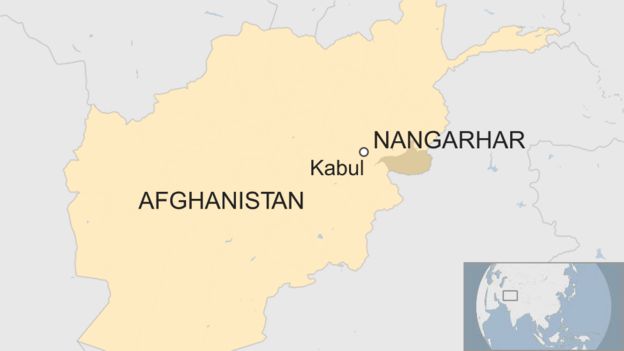
Ten days ago, a joint special forces raid between US and Afghanistan took place in the Nangarhar province of eastern Afghanistan. On Sunday, Afghan officials confirmed the killing of Abdul Hasib, leader of ISIS in the Khorasan Province. Hasib was appointed leader after his predecessor Hafiz Saeed was killed in a US drone strike nine months ago. As a result of Hasib's death, Afghan forces are now able to enter numerous villages for the first time in nine months. However, the region is not fully secure. Intense fighting and aerial bombardment are currently present in the Nangarhar province.
 
Formerly Hasib-run, the Islamic State in the Khorasan is the older Persian province that includes Afghanistan and Pakistan. The map depicts the location of Nangarhar province, a modern-day region that is within the ancient province. Click on the map to expand.
Further Reading: NY Times, FOX, Washington Post, CBS
Graphic Source: BBC
__________________________________________
This map shows the results of the landslide French election.
France
Day One
French President Emmanuel Macron will start getting his house in order on Monday after a landslide victory. Late Sunday night, Macron addressed thousands of supporters outside of the Louvre Museum in Paris, making a call for unity in the country that has seen deep divisions. Macron said, "A new page of our history has turned this evening, I want that page to be one of hope and refound trust, the renewal of our public life, will be at the base of what I do from the very first day of our presidency."
 
The map shows the results of the landslide French election. Click on the map to expand.
Graphic Source: CNN
__________________________________________
This map shows territories of ethnic groups within South Sudan.
South Sudan 
Uprooted and Fleeing
The United Nations (UN) estimated an alarming 1 million children have fled South Sudan due to civil war. The UN stated roughly 62% of the nearly 2 million South Sudanese refugees are children and more than 75,000 are alone or without their families. The numbers are daunting as the country is crippled by famine and hundreds of thousands of children are at risk of starvation in the absence of food aid. The war in South Sudan began in 2013 when President Salva Kiir of the Dinka ethnic group fired and accused his deputy Riek Machar, who belongs to the Nuer ethnic group, of attempting a coup. As a result, the country fell into conflict with the two main warring groups (Dinka and Nuer), allied along ethnic lines and fighting for control using atrocious war tactics such as ethnic cleansing.
 
The map shows territories of ethnic groups within South Sudan. Click on the map to expand.
Further Reading: Al Jazeera, BBC, Washington PostABC
Graphic Source: Genocide Watch
GeoQuestion
Friday's Answer
Q: Which bay has the highest tidal range in the world?

A: The Bay of Fundy
Located between Nova Scotia and New Brunswick in Canada, the bay is one of the 7 wonders of North America. Its unique shape amplifies the tides to as much as 16 m (56 feet) and is also renowned for geological discoveries such as dinosaur fossils and marine life such as whales.

Source
Today's Question
Q: Which country is home to the largest natural deposit of asphalt??
 
Stay tuned for Tomorrow's DailyGeo where we reveal the correct answer!

DailyGeo is daily digital communication created by AGS staff in our Headquarters for our community of Affiliates to digest on business days. Feel free to share and encourage others to become part of the community too!
 
Copyright © 2017 American Geographical Society, All rights reserved.
We understand this might not be for everyone. Although we would hate to see you go, you can unsubscribe here.

How are we doing? We want to hear your feedback on the DailyGeo - what are we doing right and what should we be doing differently. Talk to us by emailing ags@americangeo.org.
Share
Tweet
Forward