|
Navigation in the Wireless Era
New Capabilities That Were Never Possible in the History of Sailing
Historical Breakthroughs
Capt. James Cook started using triangulation and geometry with survey tools in 1758 at Fort Louisbourg in present-day Nova Scotia, Canada. Taking a "plane table" on his ship for sighting angles to landmarks on shore led to a new era of map-making and sea exploration. Over time, sailboat navigation evolved from downwind sailing in square-riggers to sailing in all directions using tacking and lift.
In the 1920s in Munich, Germany, Manfred Curry used smoke to study lift and wind flow over sails. In 1935 in Cowes, England, Uffa Fox (designer of the Albacore) showed the advantage of planing for dinghy racing. In the 1960s, the hull-testing by Frank Bethwaite and family in Sydney, Australia led to monohulls that can amazingly sail several times faster than the wind -- and to well-known models such as the Laser II, Tasar, 49er and 29er. Modern multihulls are another fundamental change, including the Tornado and Hobie Cat, Dennis Connor's 1988 America's Cup cat, the range of bluewater cruising catamarans since the 1990s, as well as Corsair and Farrier performance trimarans. Most recently, we have increasing use of foiling sailboats, that do not even have a hullspeed.
Where digital technology is involved, we are also seeing major transitions. Lithium batteries power electronics and electric motors of all sizes. Electric cars are an example of fundamental change: they are faster than race cars, may save us from global warming, and are starting to have autonomous navigation. We are also in the midst of a huge leap forward in sailboat navigation, with wireless sensors, smartphones and low-cost apps opening up new capabilities and removing monopolies. This requires a bit of a deep dive, but it seems like an appropriate time to summarize the many SailTimer innovations, as this period of remarkable technological change continues...
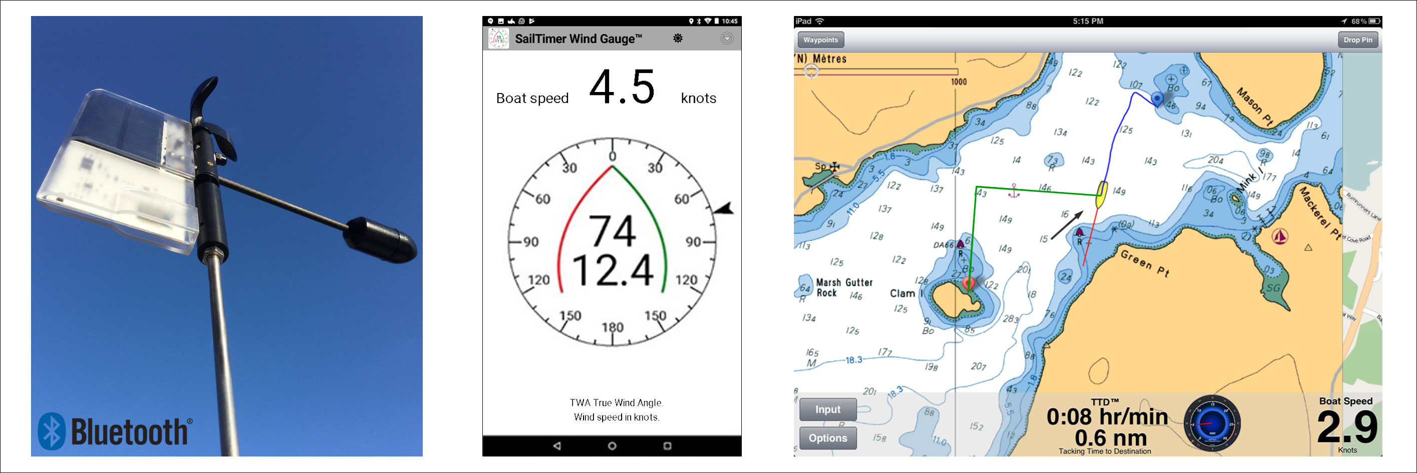
● The Helmsman's Dilemma: Generations of seafarers have needed a way to determine optimal tacking angles: Should I sail off the wind more to increase speed, or pinch closer upwind to reduce distance? No-one can do the trigonometry in their head. GPS chartplotters and MFDs have never provided a solution because they don't calculate tacking distances and have well-known problems with ETA and VMG. So the SailTimer tacking patent was filed in 2006, with the first-ever method for using tacking distances and boat speed (polar plots) to display your optimal tacks.
● Tacking distances: No other product uses tacking distance to determine optimal tacks except the SailTimer app. The logic is simple but had never been used before with sailboat tacking. Say you want to know how long it would take to go 10 miles at 5 miles per hour. 10 miles divided by 5 mph = 2 hours. There is no way to determine this correctly without including distance. Potential tacking distances are easy to measure in the age of GPS (but no other app, weather routing software, GPS chartplotter or MFD does). This changes everything; using tacking distances for sailboat navigation is a major technological advance.
● Smartphone apps: Amazingly it was just 11 years ago that apps started to be available, in 2008. The SailTimer tacking app was first released on iOS in 2009, solving a longstanding seafaring problem with the phone in your pocket. In 2013 Android 4.4 started supporting Bluetooth LE (low energy). The SailTimer Wind Instrument works with lots of apps; more than any other anemometer. Mobile apps evolve with new features all the time and new apps come out, so the Wind Instrument actually gets better over time. That was never possible before.
● Bluetooth: In 2012 SailTimer released the world's first masthead anemometer that could transmit to smartphones. Bluetooth Low Energy (LE) is the only wireless format that works with smartphones and can be powered by solar alone. Wifi uses too much power. The Wind Instrument RB™ uses Bluetooth LE and we measure power consumption in millionths of a volt, with transmissions in the range of 280' (85m) as per the specification.
● Polar Plot Learning: These graphs of boat speed from all wind directions were traditionally only theoretical "targets". They were expensive, hard to find, and were mostly only for tacticians on sponsored race boats. But SailTimer invented polar plot learning in 2005, producing hardware and software that stored actual polar data. A huge step forward in navigation technology. And in a sign of the times, there is still no GPS chartplotter or MFD with polar learning, but in the free SailTimer app you can easily use learned polars to display your boat's optimal tacks.
● The first masthead anemometer designed for sailboats: The blades on the SailTimer wind cups are shaped to spin equally well whether upright or sailing along heeling over. Standard wind cup, propeller and ultrasonic anemometers were only designed to be used upright, and do not function correctly when heeling over. For example, the air can’t flow straight through the horizontal slot on an ultrasonic when it is leaning away from the wind, giving inaccurate data. Similar problems occur on anemometers with propellers or hemishpere wind cups, when the wind hits them from underneath when sailing along heeled over.
● The new Wind Instrument RB™: Some very impressive engineering in this new model. The battery is used as a counterbalance instead of the usual brass nose cone, to reduce weight. Carbon-fiber pointer for strength and low weight. This may be the first masthead anemometer with a Replaceable Battery ("RB"), so that you don't lose the whole unit if the battery wears out. Easy to top up the battery in a wall charger before launching. Free worldwide FedEx shipping is still available. Orders ship in the sequence they are received, so order now for earliest delivery ($549.99). New stock arriving Nov. 7th.
● Digital compass in the wind direction arrow: The first masthead anemometer with a built-in digital compass, to give wind direction not just wind angle. So revolutionary that the NMEA 0183 format for marine electronics does not even include a specification for Apparent Wind Direction. Simpler installation: does not need to be calibrated to the bow of the boat. Unlike potentiometer wind sensors, there is no dead zone at the end of the rotation where the voltage starts over. Works with rotating masts. You do not also need to buy an electronic compass for the boat to get wind direction. Provides wind direction even when sliding back and forth sideways at anchor, or when docked with no GPS heading.
● Audio Navigation: No screen required. Put your phone away safe & dry – no need to try to see the screen out in the bright sun. All SailTimer apps give you the option to use a Bluetooth speaker or earbud to hear when wind conditions or boat speed change by more than a set amount. Save battery power and reduce heat in your phone/tablet.
● Small sailboats: A lot of small sailboats have been built since advent of fiberglass around 1961, and most of those are probably still in use. They have never had electronics or chartplotting. But with smartphones, trailer-sailors, beach cats and sailing dinghies can now have full chartplotting and wind electronics for the first time. The Wind Instrument RB™is solar-powered and wireless, and about the size of a handheld wind meter. No 12-volt battery required.
● The first anemometer that can be raised without lowering or climbing mast: This is a low-tech innovation, but very useful. In the past most masthead anemometers required time-consuming and expensive installation of wires down the mast and through the cabin walls. But the Wind Instrument RB™ is wireless and comes with a loop on the mounting rod, so that you can raise it on a halyard if you want to use it use right away until you can get at the masthead. Another first. There is also an optional attachment for the mainsail track in Accessories.
● Monitor wind conditions and temperature remotely: The SailTimer Wind Instrument can have an internet connection (e.g. through your smartphone). If using the Air Link to connect online through marina wifi, you can check wind conditions and temperature at your boat from home or office.
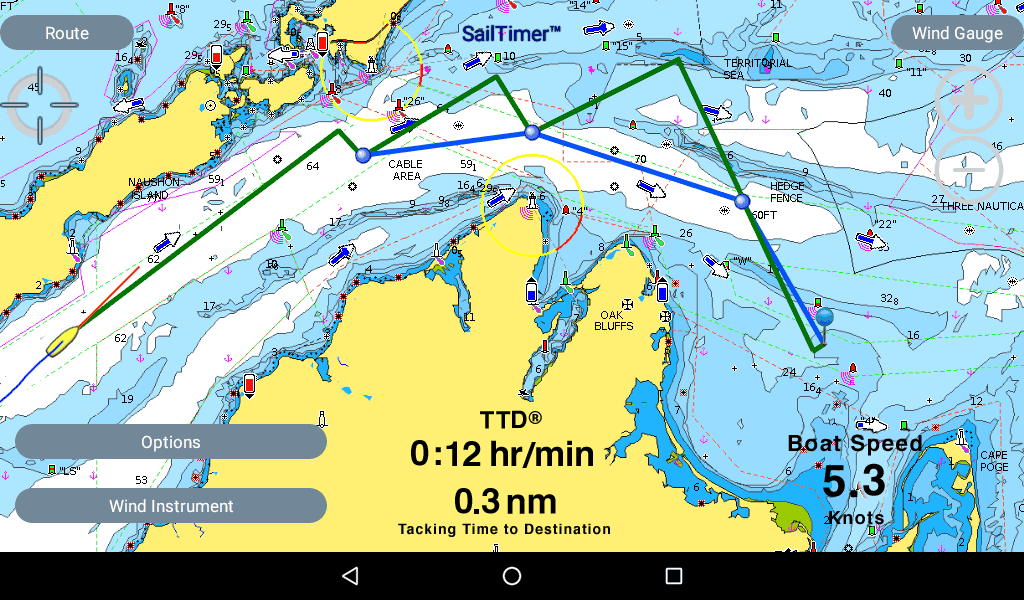
● As navigation technology continues to evolve: Finally, the screenshot below shows a tacking route on the upcoming Android version of the SailTimer chartplotter app. So far there is no way to see wind zones near channels, islands and land up ahead. But the SailTimer Wind Instrument™ is the first masthead anemometer with the option of sharing data to crowdsourced wind maps. Imagine being able to see wind zones ahead, and to display your optimal tacks through those. Stay tuned, we are working on it...
|