Fine Scale Geo-Localization of Demersal Fish With Satellite Tags (PART II)
By Jean-Christophe Sicotte-Brisson
A Pacific halibut tagged with (A) a Desert Star SeaTag GEO
Use of Geomagnetic Anomalies for
Precise Geo-localisation
Welcome back to Glacier Bay National Park! For a second consecutive month, we are addressing the potential uses of SeaTag™ for fine scale geolocalisation, this time through the potential utility of using geomagnetic anomaly data for the geolocation of demersal fishes in the North Pacific Ocean. We encourage you to read the first part of this series; if you didn't yet, you can find it here! Following the work of Nielsen et al. on migration habits of pacific halibut and other demersal fish species tracked via tidal signals among other things, we are going to discover how a magnetic sensor embedded in a pop-up tag can go a long way towards identifying precise fish locations. In this study starring Seatag-MOD, Nielsen et al. have tested how crustal anomalies in the earth's magnetic field can help us make better use of magnetometers for geolocation than use of the earth’s main magnetic field alone can. After comparing different map and tag sensing resolutions, the results are pretty exciting...
What are magnetic anomalies?
The earth's main magnetic field is created by movement of iron and other ferromagnetic elements inside its core. This huge and shifting ferromagnetic mass can in turn influence smaller ferromagnetic materials in the earth's crust, assuming a magnetic field intensity and orientation as magma hardens. This is how magnetic anomalies are formed. Simply put, they are areas at the earth's surface where the magnetic field is either dampened or amplified, (and where the magnetic field vector may point in a different direction although the present work is using field intensity only). An extreme example would be the Bangui Magnetic anomaly located in The Central African Republic. If you were to use a compass over it, it wouldn’t know where to point to!
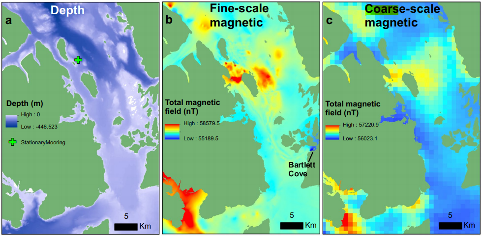
In the image below, the earth’s main magnetic field is compared to local magnetic anomalies in Glacier Bay, Alaska. Since these anomalies form randomly shaped patterns, they exhibit field intensity variability over a much smaller scale than the earth’s main field does, that is the magnetic field intensity gradient can be much steeper. By comparing these geographic patterns to SeaTag-MOD readings, Nielsen et al. were able to increase the accuracy at which they could geolocate tagged fishes. The challenge however is that you need to have a detailed map of those anomalies at hand if you wish to use them in your studies. Nielsen et al. have worked with a map generated by a nearby observatory, but also with their own self-made map. They mounted high end magnetometers on a floating vessel and scanned the seafloor to generate a fine scale map of the area. The good news is that they managed to get positive results with the readily available map, so scanning your own before every study probably won't be required, especially if you use the highest magnetic resolution given by the PSAT (SeaTag-MOD can operate at different magnetic resolutions from 1000 to 150 nT depending on the calibration technique).
How do you determine a fish position
with magnetic fields?
The original geolocation method implemented in SeaTag devices combines solar and magnetic sensors. By comparing the observed local noon time, characterised as the halfway point in time between the light sensor observed dawn and dusk, with the actual recorded time on the tag, we can deduct at which longitude the fish is located. The latitude is then determined using the strength of the magnetic signal by referring to the World Magnetic Model (WMM). This method is powerful when studying pelagic migrating fish. But, it becomes a little harder to use with bottom dwelling fish like halibuts that experience stronger anomalies closer to the seafloor and travel shorter distances. They also tend to live so deep that the light sensors become useless.
The method Nielsen et al. tested in their previous studies, which we talk about in last month’s newsletter, consists in matching the tide patterns of a specific area with the recorded depths of the satellite tag. This method has been proven to be effective, however it requires well defined hydrodynamic models, and this mostly is not the case in Alaska. Now, you get where I am going, the use of anomalies in the earth’s magnetic field has been proposed by Nielsen et al. as a solution for deepwater fish geolocation. In the image above, even the coarse scale map of magnetic anomalies in Glacier Bay can offer a precision in the hundreds of meters.
Are PSAT's useful for magnetic geolocation?
Magnetic field data can be of great value for geolocation. It is no wonder that the US Air Force have recently manifested their interest in augmenting that good old GPS (which doesn’t work underwater by the way, in case you ever wondered why PSATs never incorporated this technology) for magnetic field geolocation. Have a look at this article on the subject, you can even see a photo of NOAA’s magnetic anomaly map. At DSS, we might not have a budget of $161 billion like the Air Force does, but if magnetic fields are good enough to coordinate planes flying at a speed of 1800 miles an hour, tracking a fish shouldn’t be too hard!
In this article, Nielsen et al. share some pro tips on how to make the most of your PSAT studies when incorporating magnetic data. One thing you should do according to the authors is to make an assessment of your study area. Make sure you have access to a well defined map of magnetic anomalies and other geographic particularities, like man-made structures, for instance. These structures, i.e. shipwrecks and underwater cables, can emit their own magnetic field and thus help indicate a satellite tag's position - or introduce errors if unknown. It is interesting to note that some fish species can manifest site fidelity near those structures. They can basically make a shipwreck their home. When this happens, magnetic data might reveal this behavior. Another example of features that can increase the performance of magnetic geolocation are the anomaly stripes caused by seafloor spreading. Whenever a fish crosses those perpendicularly, there is a punctual change in the magnetic signal, and it helps indicate where the fish is going. That being said, the more you know your study area, the easier it is to make sense out of magnetic data.
This Seatag newsletter miniseries on small scale fish geolocation strategies has been really fun to write. We really enjoy when users share their techniques and discoveries made with PSATs, no matter if it's in a scientific paper or on a fishing trip! Nielsen et al. have shown that there are multiple ways to implement geolocation with PSATs, and magnetic anomalies combined with depth sensing can be a great solution when studying demersal fish. Stay tuned for next month’s article, and until then, happy tagging!